
Pan Borneo Highway (Sarawak)
Overview
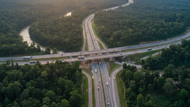
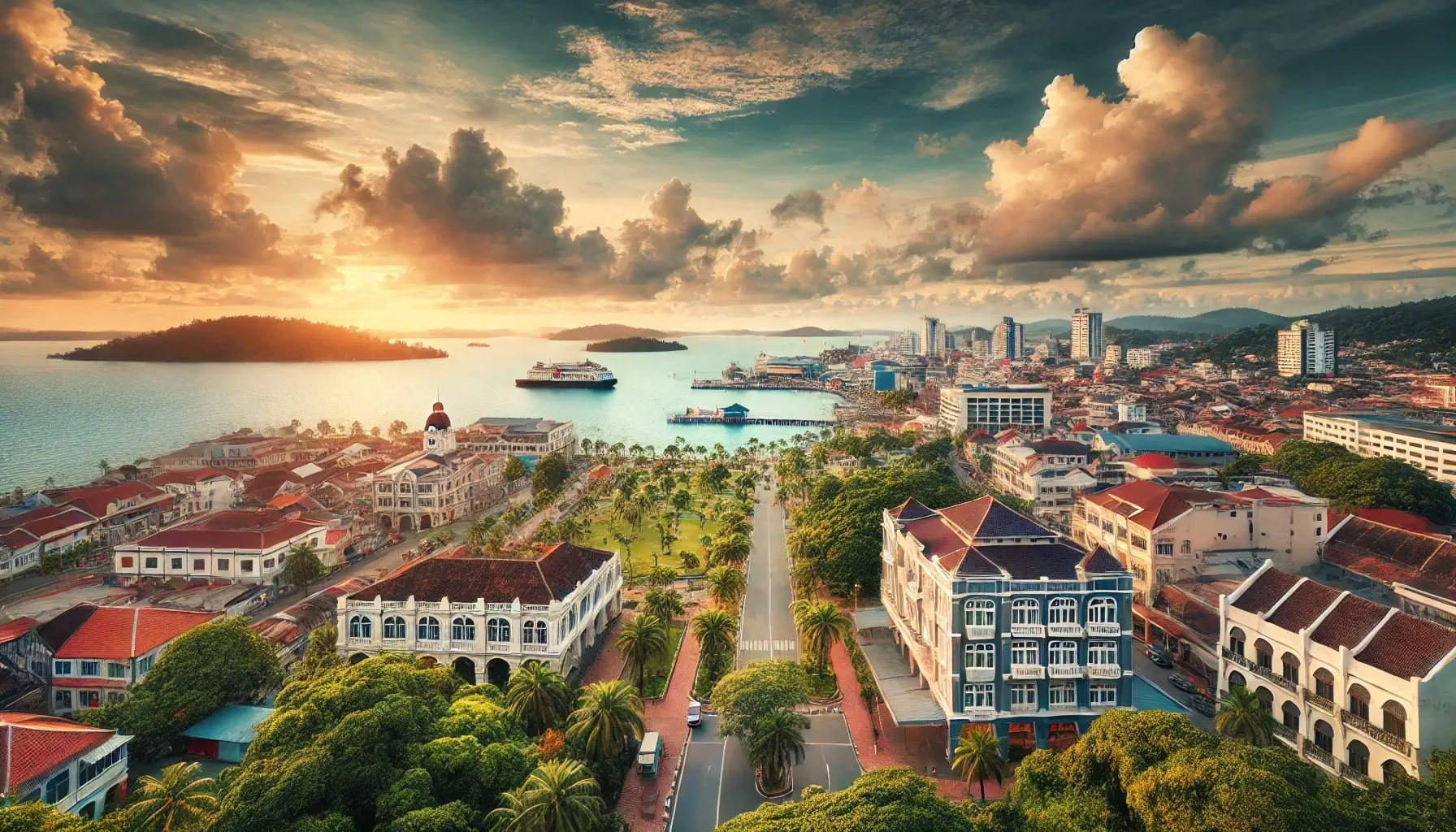
The Pan Borneo Highway (Sarawak) is a vital road network that spans across the Malaysian states of Sarawak and Sabah. Stretching approximately 1,080 km within Sarawak alone, this highway serves as the backbone of East Malaysia’s transport system. Originally conceptualized to improve regional connectivity, the Pan Borneo Highway has been upgraded in phases since its inception, with the latest enhancements completed in 2020 under the supervision of the Lebuhraya Borneo Utara Sdn Bhd (LBU). This expressway plays a critical role in facilitating trade, tourism, and logistics, connecting urban centers, rural communities, and border towns across the region.
Route Overview
The Pan Borneo Highway runs predominantly in an east–west direction, linking Sarawak’s western border near Kuching to its eastern border adjoining Sabah. Within Sarawak, the highway carries the Federal Route 1 and 13 designations, connecting key towns and cities including Kuching, Sibu, Bintulu, and Miri. The route offers a seamless journey across diverse terrains, from coastal plains to hilly interiors, making it a crucial corridor for both passenger and freight transport.
Key Cities and Exits
The Pan Borneo Highway features numerous interchanges and access points to major towns:
- Kuching – Starting point with connections to Jalan Datuk Patinggi Ahmad Zaidi and Kuching International Airport.
- Sibu – Key junction linking rural towns and ferry terminals.
- Bintulu – Industrial hub with exits to Samalaju Industrial Park and Bintulu Port.
- Miri – Northern gateway to Sarawak, connecting to Brunei and Sabah via secondary highways.
Additional exits provide access to scenic towns, local markets, and heritage sites, offering travelers both convenience and cultural exposure.
Scenic Highlights
Travelers on the Pan Borneo Highway enjoy stunning natural landscapes, including:
- Rajang River vistas near Sibu.
- Bintulu coastal views with nearby palm oil and coconut plantations.
- Rolling hilly terrains and lush rainforests along the central Sarawak corridor.
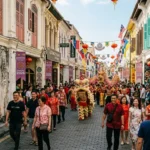
- Heritage towns such as Kapit and Kuching’s Old Town, offering glimpses into Sarawakian culture.
This combination of natural beauty and cultural landmarks makes the highway a scenic route for road trips.
Rest & Service Areas (R&R)
The highway features several Rest and Service Areas (R&R) for travelers’ convenience:
- Kuching R&R – Includes petrol stations, food courts, and ATMs.
- Bintulu R&R – Offers prayer rooms, clean toilets, and local snacks.
- Sibu R&R – Scenic stop with picnic areas and convenience stores.
These stops provide a safe and comfortable environment for long-distance drivers.
Toll Information
The Pan Borneo Highway in Sarawak primarily operates on an open toll system in certain upgraded segments. Accepted payment methods include Touch ‘n Go, SmartTAG, and RFID. Sample toll rates:
- Kuching to Sibu: Approximately RM 15 per car.
- Bintulu to Miri: Approximately RM 20 per car.
Toll collection helps maintain road quality and ensures efficient highway operations.
Safety & Facilities
Safety is a priority along the Pan Borneo Highway:
- Standard speed limits range from 90–110 km/h on open stretches.
- PLUSRonda and highway patrols operate regularly for assistance.
- Emergency lanes and breakdown services are available at strategic points.
- Emergency hotlines are accessible for roadside assistance and accidents.
These measures ensure a safe and smooth driving experience for commuters and tourists alike.
Useful Apps & Resources
Drivers can use the following tools for updates:
- LBU Official Website – Provides news on construction, maintenance, and tolls.
- Waze & Google Maps – Real-time traffic and route planning.
- PLUS Highway Apps – For emergency services, rest area locations, and live updates.
These apps help ensure informed travel along the highway.
Travel Tips
- Plan ahead during festive seasons, as traffic increases significantly.
- Fuel up at major towns, especially for rural stretches.
- Follow speed limits and adhere to Malaysian highway etiquette.
- Best travel times: early mornings or late evenings to avoid congestion in urban hubs.
Connecting Expressways
The Pan Borneo Highway links to several major expressways and routes:
- Jalan Kuching–Serian (Federal Route 1)
- Jalan Bintulu–Miri (Federal Route 13)
- Access roads to Brunei and Sabah via border crossings.
These connections enhance regional connectivity and cross-border trade.
Summary Table
| Parameter | Details |
|---|---|
| Expressway Name | Pan Borneo Highway (Sarawak) |
| Code | Federal Route 1 & 13 |
| Total Length | 1,080 km |
| Operator | Lebuhraya Borneo Utara Sdn Bhd |
| Start & End Points | Kuching – Miri |
| States Covered | Sarawak |
| Average Speed Limit | 90–110 km/h |
| Toll Type | Open/Closed (depending on segment) |

- Temperature
- Precipitation
- Rain Chance
- Wind
- Humidity
- Pressure
Conclusion
The Pan Borneo Highway is more than just a road; it is a vital artery driving economic growth, regional trade, and tourism in Sarawak. By connecting major cities, towns, and industrial hubs, the highway significantly enhances accessibility and travel efficiency. For drivers, tourists, and logistics operators, it represents a modern, scenic, and well-maintained route that showcases the best of Sarawak’s natural and cultural landscapes.
| Road Name | Road Short Name | Code | Main Route |
|---|---|---|---|
| North–South Expressway (PLUS) | North–South Expressway | PLUS / E1, E2 | Bukit Kayu Hitam – Johor Bahru |
| North–South Expressway Central Link | ELITE Expressway | E6 | Shah Alam – Nilai North |
| New Klang Valley Expressway | NKVE | E1 | Kuala Lumpur – Klang |
| Federal Highway | Federal Highway | E5 | Kuala Lumpur – Klang |
| Damansara–Puchong Expressway | LDP | E11 | Damansara – Puchong |
| Shah Alam Expressway | KESAS | E5 | Sri Petaling – Pandamaran |
| New Pantai Expressway | NPE | E10 | Subang – Bangsar |
| Maju Expressway | MEX | E20 | Kuala Lumpur – Putrajaya |
| Kajang Dispersal Link | SILK | E18 | Kajang – Semenyih |
| Kajang–Seremban Highway | LEKAS | E21 | Kajang – Seremban |
| South Klang Valley Expressway | SKVE | E26 | Pulau Indah – Kajang |
| Guthrie Corridor Expressway | GCE | E35 | Shah Alam – Rawang |
| Kuala Lumpur–Karak Expressway | KLK | E8 | Gombak – Karak |
| East Coast Expressway Phase 1 | LPT1 | E8 | Karak – Kuantan |
| East Coast Expressway Phase 2 | LPT2 | E8 | Kuantan – Kuala Nerus |
| Butterworth–Kulim Expressway | BKE | E15 | Butterworth – Kulim |
| Penang Bridge | Penang Bridge | E36 | Gelugor – Perai |
| Sultan Abdul Halim Muadzam Shah Bridge | Second Penang Bridge | E28 | Batu Maung – Batu Kawan |
| Johor Bahru Eastern Dispersal Link | EDL | E14 | Pandan – CIQ Johor |
| Senai–Desaru Expressway | SDE | E22 | Senai – Desaru |
| Second Link Expressway | Linkedua | E3 | Senai – Tuas (Singapore) |
| Kuala Lumpur–Seremban Expressway | KL–Seremban | E37 | Kuala Lumpur – Seremban |
| Cheras–Kajang Expressway | Grand Saga | E7 | Cheras – Kajang |
| Kuala Lumpur–Putrajaya Expressway | MEX | E20 | KL – Putrajaya – KLIA |
| West Coast Expressway | WCE | E32 | Taiping – Banting |
| Central Spine Road | CSR | – | Bentong – Kuala Krai |
| Federal Route 1 | Federal Route 1 | FT1 | Bukit Kayu Hitam – Johor Bahru |
| Federal Route 2 | Federal Route 2 | FT2 | Port Klang – Kuantan |
| Federal Route 3 | Federal Route 3 | FT3 | Johor Bahru – Rantau Panjang |
| Federal Route 4 | Federal Route 4 | FT4 | Gerik – Jeli |
| Federal Route 5 | Federal Route 5 | FT5 | Ipoh – Johor Bahru |
| Federal Route 8 | Federal Route 8 | FT8 | Kuala Lumpur – Kota Bharu |
| Federal Route 9 | Federal Route 9 | FT9 | Karak – Tampin |
| Federal Route 10 | Federal Route 10 | FT10 | Temerloh – Gemas |
| Federal Route 24 | Federal Route 24 | FT24 | Muar – Yong Peng |
| Federal Route 50 | Federal Route 50 | FT50 | Batu Pahat – Kluang – Jemaluang |
| Federal Route 51 | Federal Route 51 | FT51 | Melaka City – Alor Gajah |
| Federal Route 54 | Federal Route 54 | FT54 | Kuala Lumpur – Kuala Selangor |
| Federal Route 76 | Federal Route 76 | FT76 | Kuala Kangsar – Baling – Kulim |
| Federal Route 67 | Federal Route 67 | FT67 | Sungai Petani – Kuala Ketil |
| Pan Borneo Highway (Sabah) | Pan Borneo Sabah | AH150 / PBHS | Kota Kinabalu – Tawau |
| Kimanis–Keningau Highway | Kimanis–Keningau Road | – | Kimanis – Keningau |
| Kota Belud–Ranau Road | Kota Belud–Ranau | – | Coastal – Interior link |
| Pan Borneo Highway (Sarawak) | Pan Borneo Sarawak | AH150 / PBHS | Telok Melano – Miri |
| Kuching–Serian Road | Kuching–Serian | – | Kuching – Serian |
| Bintulu–Miri Coastal Road | Bintulu–Miri Coastal | – | Bintulu – Miri |
| Kota Bharu–Kuala Krai Expressway | KBKK Expressway | KBKK | Kota Bharu – Kuala Krai |
| Pan Borneo Highway (Overall) | Pan Borneo Highway | PBH | Across Sabah & Sarawak |


Comments are closed.