
North–South Expressway (PLUS)
Overview
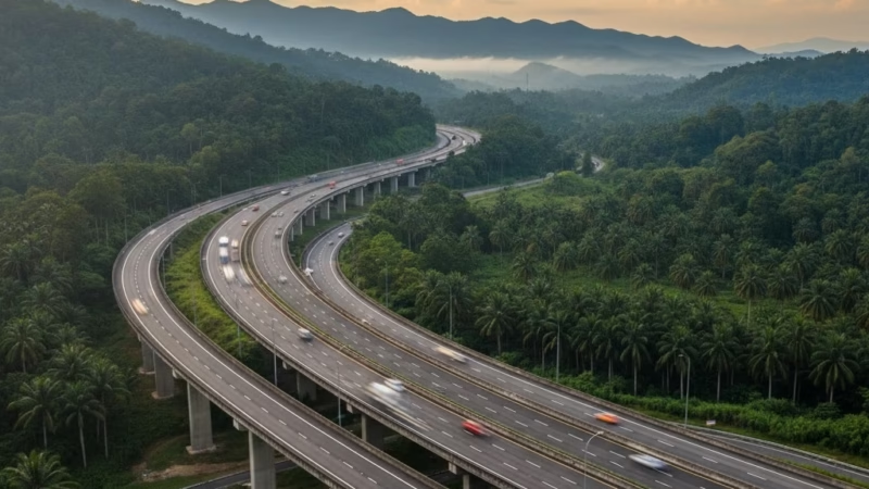
The North–South Expressway (PLUS) is Malaysia’s longest and most significant expressway, stretching over 772 km from Bukit Kayu Hitam in Kedah to Johor Bahru in Johor. Completed in 1994 and operated by PLUS Malaysia Berhad, it serves as the main artery connecting Peninsular Malaysia’s northern and southern regions. This expressway plays a vital role in trade, tourism, and logistics, facilitating smooth transport for commuters, commercial vehicles, and travelers.
Route Overview
The North–South Expressway runs primarily in a north–south direction, linking major cities and economic hubs.
- Expressway Codes: E1 (North Section), E2 (South Section)
- Start Point: Bukit Kayu Hitam, Kedah
- End Point: Johor Bahru, Johor
Key milestones along the route include Alor Setar, Penang (via Penang Bridge connector), Ipoh, Kuala Lumpur, Seremban, Melaka, and Senai. The expressway forms the backbone of Peninsular Malaysia’s road network, supporting both long-haul freight and daily commuters.
Key Cities and Exits
The North–South Expressway passes through several major towns and cities with strategic interchanges:
- Kedah: Bukit Kayu Hitam, Alor Setar
- Penang: Butterworth, Penang Bridge (E36 link)
- Perak: Ipoh, Kampar, Tapah
- Selangor / Kuala Lumpur: Rawang, Shah Alam, Kuala Lumpur
- Negeri Sembilan: Seremban, Port Dickson (via ELITE link)
- Melaka: Ayer Keroh
- Johor: Kulai, Senai, Johor Bahru
Each exit connects to local towns, industrial areas, and tourist destinations, making it highly accessible for both travelers and logistics operations.
Scenic Highlights
Travelers along the North–South Expressway enjoy a variety of landscapes:
- Northern Section: Lush paddy fields and rolling hills in Kedah and Penang
- Central Section: Limestone hills and forests around Ipoh
- Southern Section: Plantation estates and coastal views near Melaka and Johor
Notable landmarks visible from the expressway include the Penang Bridge, Kellie’s Castle near Ipoh, and historic towns in Melaka.
Rest & Service Areas (R&R)
Several R&R stops along the route provide convenience for travelers:
- Northern R&R: Gurun, Sungai Perak
- Central R&R: Tapah, Rawang, Seremban
- Southern R&R: Ayer Keroh, Pagoh, Yong Peng
Amenities: Petrol stations, 24-hour food courts, prayer rooms (surau), ATMs, clean toilets, and convenience stores. Some R&Rs offer scenic spots for relaxation and local cuisine specialties.
Toll Information
The North–South Expressway uses a closed toll system, meaning toll charges are calculated based on distance traveled.
Payment Methods: Touch ‘n Go, SmartTAG, RFID
Sample Rates:
- Bukit Kayu Hitam → Kuala Lumpur: ~RM 85 (Class 1 vehicle)
- Kuala Lumpur → Johor Bahru: ~RM 62 (Class 1 vehicle)
Tolls are automated at most plazas, ensuring smooth traffic flow.
Safety & Facilities
- Speed Limit: 110 km/h (standard), reduced in urban zones
- Emergency Services: PLUSRonda patrol vehicles, emergency telephones, and breakdown services
- Lane Details: 2–3 lanes per direction, dedicated emergency lanes available at strategic locations
- Safety Features: Roadside reflectors, CCTV surveillance, and rest area monitoring
Useful Apps & Resources
- PLUS Mobile App: Toll info, R&R locations, travel advisories
- Google Maps / Waze: Real-time traffic updates
- Official Website: www.plus.com.my
- Emergency Hotline: 1800-88-0000
Travel Tips
- Best Travel Times: Early morning or late evening to avoid peak traffic
- Driving Etiquette: Keep left unless overtaking; adhere to speed limits
- Long-Distance Planning: Factor in fuel stops, rest breaks, and toll charges
- Tourist Tip: Plan detours to scenic R&Rs and nearby attractions for a more enjoyable journey
Connecting Expressways
The North–South Expressway connects with several major expressways:
- ELITE (E6): Connects Kuala Lumpur to Nilai / KLIA
- NKVE (E1): Links Kuala Lumpur to Klang / Port Klang
- Penang Bridge (E36): Access to Penang Island
- South Klang Valley Expressway (SKVE): Provides alternate southern routes
Summary Table
| Feature | Details |
|---|---|
| Expressway Name | North–South Expressway |
| Code | PLUS / E1, E2 |
| Total Length | 772 km |
| Operator | PLUS Malaysia Berhad |
| Start & End Points | Bukit Kayu Hitam – Johor Bahru |
| States Covered | Kedah, Penang, Perak, Selangor, Kuala Lumpur, Negeri Sembilan, Melaka, Johor |
| Average Speed Limit | 110 km/h |
| Toll Type | Closed System |
Conclusion
The North–South Expressway is Malaysia’s most crucial roadway, linking the northern and southern regions while supporting commerce, tourism, and daily commuting. With modern tolling, safety measures, and convenient rest stops, it remains the backbone of Peninsular Malaysia’s transport infrastructure. Whether you are traveling for business or leisure, the NSE ensures a smooth and scenic journey across the country.
| Road Name | Road Short Name | Code | Main Route |
|---|---|---|---|
| North–South Expressway (PLUS) | North–South Expressway | PLUS / E1, E2 | Bukit Kayu Hitam – Johor Bahru |
| North–South Expressway Central Link | ELITE Expressway | E6 | Shah Alam – Nilai North |
| New Klang Valley Expressway | NKVE | E1 | Kuala Lumpur – Klang |
| Federal Highway | Federal Highway | E5 | Kuala Lumpur – Klang |
| Damansara–Puchong Expressway | LDP | E11 | Damansara – Puchong |
| Shah Alam Expressway | KESAS | E5 | Sri Petaling – Pandamaran |
| New Pantai Expressway | NPE | E10 | Subang – Bangsar |
| Maju Expressway | MEX | E20 | Kuala Lumpur – Putrajaya |
| Kajang Dispersal Link | SILK | E18 | Kajang – Semenyih |
| Kajang–Seremban Highway | LEKAS | E21 | Kajang – Seremban |
| South Klang Valley Expressway | SKVE | E26 | Pulau Indah – Kajang |
| Guthrie Corridor Expressway | GCE | E35 | Shah Alam – Rawang |
| Kuala Lumpur–Karak Expressway | KLK | E8 | Gombak – Karak |
| East Coast Expressway Phase 1 | LPT1 | E8 | Karak – Kuantan |
| East Coast Expressway Phase 2 | LPT2 | E8 | Kuantan – Kuala Nerus |
| Butterworth–Kulim Expressway | BKE | E15 | Butterworth – Kulim |
| Penang Bridge | Penang Bridge | E36 | Gelugor – Perai |
| Sultan Abdul Halim Muadzam Shah Bridge | Second Penang Bridge | E28 | Batu Maung – Batu Kawan |
| Johor Bahru Eastern Dispersal Link | EDL | E14 | Pandan – CIQ Johor |
| Senai–Desaru Expressway | SDE | E22 | Senai – Desaru |
| Second Link Expressway | Linkedua | E3 | Senai – Tuas (Singapore) |
| Kuala Lumpur–Seremban Expressway | KL–Seremban | E37 | Kuala Lumpur – Seremban |
| Cheras–Kajang Expressway | Grand Saga | E7 | Cheras – Kajang |
| Kuala Lumpur–Putrajaya Expressway | MEX | E20 | KL – Putrajaya – KLIA |
| West Coast Expressway | WCE | E32 | Taiping – Banting |
| Central Spine Road | CSR | – | Bentong – Kuala Krai |
| Federal Route 1 | Federal Route 1 | FT1 | Bukit Kayu Hitam – Johor Bahru |
| Federal Route 2 | Federal Route 2 | FT2 | Port Klang – Kuantan |
| Federal Route 3 | Federal Route 3 | FT3 | Johor Bahru – Rantau Panjang |
| Federal Route 4 | Federal Route 4 | FT4 | Gerik – Jeli |
| Federal Route 5 | Federal Route 5 | FT5 | Ipoh – Johor Bahru |
| Federal Route 8 | Federal Route 8 | FT8 | Kuala Lumpur – Kota Bharu |
| Federal Route 9 | Federal Route 9 | FT9 | Karak – Tampin |
| Federal Route 10 | Federal Route 10 | FT10 | Temerloh – Gemas |
| Federal Route 24 | Federal Route 24 | FT24 | Muar – Yong Peng |
| Federal Route 50 | Federal Route 50 | FT50 | Batu Pahat – Kluang – Jemaluang |
| Federal Route 51 | Federal Route 51 | FT51 | Melaka City – Alor Gajah |
| Federal Route 54 | Federal Route 54 | FT54 | Kuala Lumpur – Kuala Selangor |
| Federal Route 76 | Federal Route 76 | FT76 | Kuala Kangsar – Baling – Kulim |
| Federal Route 67 | Federal Route 67 | FT67 | Sungai Petani – Kuala Ketil |
| Pan Borneo Highway (Sabah) | Pan Borneo Sabah | AH150 / PBHS | Kota Kinabalu – Tawau |
| Kimanis–Keningau Highway | Kimanis–Keningau Road | – | Kimanis – Keningau |
| Kota Belud–Ranau Road | Kota Belud–Ranau | – | Coastal – Interior link |
| Pan Borneo Highway (Sarawak) | Pan Borneo Sarawak | AH150 / PBHS | Telok Melano – Miri |
| Kuching–Serian Road | Kuching–Serian | – | Kuching – Serian |
| Bintulu–Miri Coastal Road | Bintulu–Miri Coastal | – | Bintulu – Miri |
| Kota Bharu–Kuala Krai Expressway | KBKK Expressway | KBKK | Kota Bharu – Kuala Krai |
| Pan Borneo Highway (Overall) | Pan Borneo Highway | PBH | Across Sabah & Sarawak |


Comments are closed.